Skip to content

Minnesota lake explorer

Lakes

Minnesota’s lakes are easier to explore when the choices are organized by real trip questions: Which waters are largest, deepest, clearest, easiest to plan around, best known for fishing, or simply interesting enough to make you click? This page is a starting hub for comparing lake scale, county context, regional geography, and recreation style before opening a detailed lake profile. Use the sections below to move from broad discovery into more specific planning without losing the map, county, and source-backed structure of the site.

  • 11,842 lakes and countingStart broad, then narrow by county, region, size, use, and lake character.
  • Find the right lake styleCompare big water, clear water, fishing destinations, metro favorites, and odd-name discoveries.
  • Stay connected to contextEvery card points toward a lake page, county page, or regional guide instead of a dead-end thumbnail.
Minnesota county map organized into the five lake regions used for browsing MinnesotaLakes.info

Largest Lakes

Review largest lake guides

Start with Minnesota’s biggest waters when you want scale: broad horizons, island routes, resort corridors, long boat rides, and lake systems that shape entire counties. These cards help visitors compare major destinations by geography and trip style before opening a detailed lake page. Use this section for big-water planning, cabin research, fishing context, and deciding whether a lake feels like a quick stop, a weekend base, or a full destination.

Lake Superior largest lakes guide image for Minnesota lake planning. Lake Superior Cook County · 1,625,846 Acres Lake Superior anchors the North Shore experience with massive freshwater scale, rocky shoreline scenery, harbor towns, trails, waterfalls, and weather that can change a trip quickly. Open this guide when you want the largest-water context before comparing inland Cook County lakes, shoreline overlooks, and northeast Minnesota planning routes. Open Lake Superior big-water guide Lower Red Lake largest lakes guide image for Minnesota lake planning. Lower Red Lake Beltrami County · 164,520 Acres Lower Red Lake is one of Minnesota’s defining northern waters: broad, open, and tied to Red Lake Nation country. This card belongs in the largest-lakes section because visitors need scale, region, and planning context before comparing access, nearby communities, fishing focus, and the surrounding Northwest Minnesota lake corridor. Explore Lower Red Lake scale Lake Mille Lacs largest lakes guide image for Minnesota lake planning. Lake Mille Lacs Mille Lacs County · 128,251 Acres Lake Mille Lacs is a major central Minnesota water with big views, resort towns, winter and summer recreation, and a strong place in the state’s lake identity. Use this guide when comparing large-lake trips that can combine fishing, boating, public access, scenic shoreline drives, and nearby county planning. Open the Lake Mille Lacs guide Leech Lake largest lakes guide image for Minnesota lake planning. Leech Lake Cass County · 103,040 Acres Leech Lake gives visitors a north-central big-water option with bays, islands, resort areas, and strong links to Cass County lake culture. It is useful for comparing large lake travel where fishing, cabins, wooded shorelines, boat routes, and nearby communities all matter in one trip plan. Compare Leech Lake trip options Lake Winnibigoshish largest lakes guide image for Minnesota lake planning. Lake Winnibigoshish Cass County · 56,472 Acres Lake Winnibigoshish, often shortened to Winnie, is a broad Cass County destination surrounded by forested lake country. This card helps visitors separate it from nearby Leech, Cass, and smaller lakes by focusing on scale, northern scenery, fishing interest, and the kind of open-water planning big lakes require. Open Lake Winnibigoshish profile Lake of the Woods largest lakes guide image for Minnesota lake planning. Lake of the Woods Lake of the Woods County · 305,578 Acres Lake of the Woods belongs on any largest-lakes shortlist because it reaches far beyond a single shoreline town. Use this card for border-water context, island and bay planning, winter and summer fishing interest, and a better sense of how northwest Minnesota lake trips can feel remote, expansive, and multi-day. Explore Lake of the Woods Rainy Lake largest lakes guide image for Minnesota lake planning. Rainy Lake St. Louis County · 44,591 Acres Rainy Lake is a northeastern gateway water with island routes, forested shorelines, and a national-park-style feel near the Canadian border. Open this guide when you want a large lake that feels more wilderness-oriented than resort-corridor-focused, while still connecting to communities, boating, and regional travel routes. Plan around Rainy Lake Lake Vermilion largest lakes guide image for Minnesota lake planning. Lake Vermilion St. Louis County · 25,798 Acres Lake Vermilion is known for islands, bays, pine shoreline, and a strong northern Minnesota cabin-and-boat identity. The lake works well for visitors comparing a large scenic destination with many shoreline experiences rather than one simple beach stop or single access point. Open Lake Vermilion guide Kabetogama Lake largest lakes guide image for Minnesota lake planning. Kabetogama Lake St. Louis County · 24,034 Acres Kabetogama Lake sits in a northeastern landscape where forest, islands, resort bases, and national park access shape the trip. It is included here for visitors comparing large northern waters that reward longer planning, boat-based exploration, and a slower pace than a quick metro lake visit. Explore Kabetogama Lake
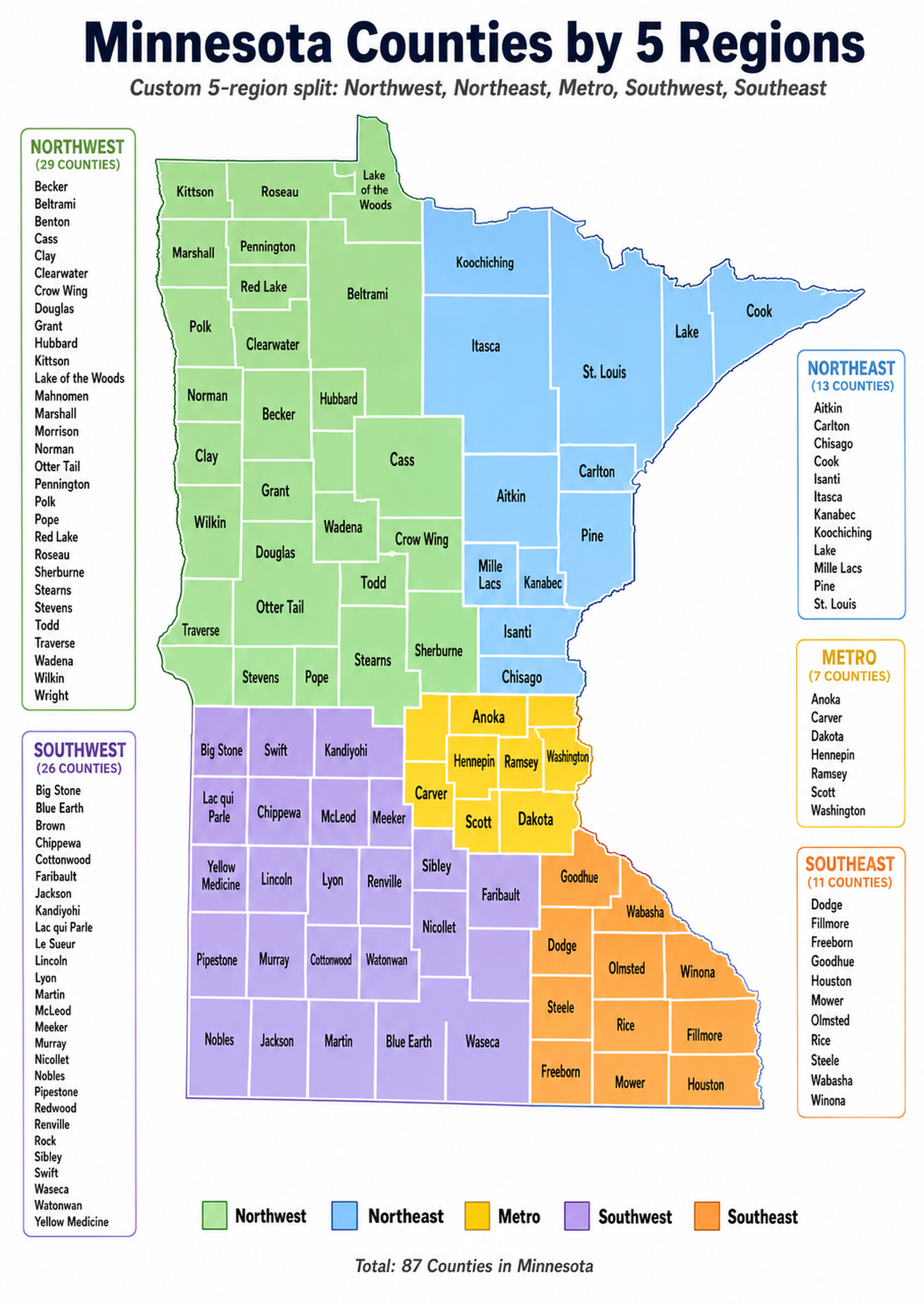
Deepest Lakes

Compare deep-water lake guides

Deep lakes can feel completely different from shallow prairie or metro waters. They often invite questions about cold water, steep shorelines, clear basins, boat safety, fish habitat, and how depth changes the way people swim, paddle, or plan a day on the water. This section is written as a planning doorway, not a claim that every visit is the same in every season.

Lake Superior deepest lakes guide image for Minnesota lake planning. Lake Superior Cook County · 1,625,846 Acres Lake Superior gives Minnesota its most dramatic deep-water setting, with cold water, exposed shoreline, rocky points, and conditions that deserve extra planning. Open the guide when depth, scale, weather, and North Shore travel context matter more than a simple inland-lake comparison. Open Superior depth context Saganaga Lake deepest lakes guide image for Minnesota lake planning. Saganaga Lake Cook County · 6,985 Acres Saganaga Lake sits in far northeastern lake country where depth, islands, remote routes, and canoe-country planning come together. This card is for visitors comparing deep northern water with a more rugged travel style than a beach-and-cabin weekend. Explore Saganaga Lake depth Big Trout Lake deepest lakes guide image for Minnesota lake planning. Big Trout Lake Crow Wing County · 1,366 Acres Big Trout Lake stands out in Crow Wing County because depth changes the way the lake is used, studied, and experienced. Open this profile when comparing Brainerd-area lakes that are not just large or popular, but structurally different beneath the surface. Open Big Trout Lake guide Ten Mile Lake deepest lakes guide image for Minnesota lake planning. Ten Mile Lake Cass County · 5,080 Acres Ten Mile Lake is a Cass County deep-water destination that fits visitors looking beyond simple acreage rankings. It is useful for comparing clear, cold, structured lakes with cabin-country planning, public access questions, and a quieter northwoods feel. Compare Ten Mile Lake Carlos Lake deepest lakes guide image for Minnesota lake planning. Carlos Lake Douglas County · 2,605 Acres Carlos Lake is part of the Alexandria-area lake landscape, where depth, recreation, shoreline use, and nearby communities all shape the visit. Open this guide when you want a western Minnesota lake with more structure than a quick surface-area ranking explains. Open Carlos Lake profile Grindstone Lake deepest lakes guide image for Minnesota lake planning. Grindstone Lake Pine County · 533 Acres Grindstone Lake is smaller than many headline lakes, but depth gives it a distinct planning role. The lake belongs here because visitors comparing Pine County options may care about cold-water character, shoreline setting, and how a deep basin changes use. Explore Grindstone Lake Crane Lake deepest lakes guide image for Minnesota lake planning. Crane Lake St. Louis County · 2,921 Acres Crane Lake connects visitors to a northeastern water route where depth, forest, islands, and travel corridors matter together. It is a strong card for people comparing deep northern lake experiences that can lead into wider border-country exploration. Open Crane Lake guide Lower LaSalle Lake deepest lakes guide image for Minnesota lake planning. Lower LaSalle Lake Hubbard County · 238 Acres Lower LaSalle Lake is a compact Hubbard County lake whose depth makes it more interesting than its acreage alone suggests. Use this profile when comparing smaller lakes with unusually strong depth character and a different planning feel than broad, shallow water. Review Lower LaSalle Lake Rainy Lake deepest lakes guide image for Minnesota lake planning. Rainy Lake St. Louis County · 44,591 Acres Rainy Lake combines large-water scale with northeastern depth, island routes, and border-country scenery. This guide helps visitors think about more than size: boat travel, weather, shoreline complexity, and the planning difference between a lake stop and a lake-based trip. Plan a Rainy Lake trip

Clearest Lakes

Browse clear-water lake ideas

Clear-water planning is about more than a pretty view. Visitors often use clarity as a clue for swimming appeal, shoreline feel, paddling scenery, photography, plant growth, and how a lake might feel from a dock or public access. These cards keep the language practical and careful: they help people compare clear-water destinations without making unsupported promises about conditions on a specific day.

Lake Vermilion clearest lakes guide image for Minnesota lake planning. Lake Vermilion St. Louis County · 25,798 Acres Lake Vermilion is a scenic northern lake where clear-water appeal blends with islands, rock, forest, and cabin-country planning. Use this guide when the goal is a lake that feels visually rich as well as large enough for extended exploring. Explore Vermilion clear water Crane Lake clearest lakes guide image for Minnesota lake planning. Crane Lake St. Louis County · 2,921 Acres Crane Lake is useful for visitors comparing clear northern water with a route-based feel. The lake is not just a scenic stop; it can become part of a longer forest, island, and border-country itinerary. Open Crane Lake scenery guide Lake Minnewaska clearest lakes guide image for Minnesota lake planning. Lake Minnewaska Pope County · 8,050 Acres Lake Minnewaska gives west-central visitors a larger water option with open views, community access, and strong trip-planning value. This card helps people compare clear-water appeal with towns, beaches, parks, and drive-friendly lake routes. Plan Lake Minnewaska Bad Medicine Lake clearest lakes guide image for Minnesota lake planning. Bad Medicine Lake Becker County · 803 Acres Bad Medicine Lake stands out as a Becker County destination where the name, setting, and clear-water interest make visitors pause. Use this guide when comparing northwestern lakes that feel distinctive without needing big-water scale. Explore Bad Medicine Lake Ada Lake clearest lakes guide image for Minnesota lake planning. Ada Lake Cass County · 963 Acres Ada Lake is a Cass County option for visitors comparing quieter clear-water stops near bigger destination lakes. It belongs here because smaller lake planning can be just as useful when the goal is calm water, scenery, and a less crowded feel. Open Ada Lake guide Koronis Lake clearest lakes guide image for Minnesota lake planning. Koronis Lake Stearns County · 2,968 Acres Koronis Lake helps visitors compare central Minnesota lake planning with clear-water appeal, public access questions, and nearby community routes. Open this guide when a lake trip needs to balance scenery with practical drive-time planning. Compare Koronis Lake Rush Lake clearest lakes guide image for Minnesota lake planning. Rush Lake Crow Wing County · 858 Acres Rush Lake works as a Crow Wing County card for visitors comparing clear-water recreation in a region better known for big resort lakes. It is useful when you want a smaller lake profile connected to broader Brainerd-area planning. Review Rush Lake options Sylvan Lake clearest lakes guide image for Minnesota lake planning. Sylvan Lake Morrison County · 256 Acres Sylvan Lake gives Morrison County visitors a smaller clear-water planning option where local access and lake character matter more than fame. Open this profile when comparing lakes that may fit a quiet day rather than a major destination trip. Open Sylvan Lake profile Ten Mile Lake clearest lakes guide image for Minnesota lake planning. Ten Mile Lake Cass County · 5,080 Acres Ten Mile Lake appears again because clear-water appeal and depth can overlap. The Cass County guide helps visitors compare a lake that feels substantial, scenic, and structured without relying on a single simple ranking. Compare Ten Mile Lake clarity

Best Fishing Lakes

Open fishing lake guides

Fishing pages should guide people toward better planning, not promise catches. This section highlights lakes that are commonly discussed by anglers or are useful starting points for comparing access, size, seasonal planning, nearby services, and regional fishing culture. Open the individual lake profiles to connect a fishing idea with county context, recreation links, maps, and official resources when available.

Lake Mille Lacs best fishing lakes guide image for Minnesota lake planning. Lake Mille Lacs Mille Lacs County · 128,251 Acres Lake Mille Lacs is one of Minnesota’s best-known fishing waters and deserves planning beyond a simple name drop. Open this guide to compare big-water access, nearby communities, seasonal considerations, and the difference between a quick trip and a lake-centered fishing weekend. Plan Lake Mille Lacs fishing Leech Lake best fishing lakes guide image for Minnesota lake planning. Leech Lake Cass County · 103,040 Acres Leech Lake belongs in the fishing section because its scale, bays, resorts, and north-central location make it a major planning target. Use the guide to connect angling interest with Cass County geography, shoreline communities, and nearby large-lake alternatives. Open Leech Lake fishing guide Lake of the Woods best fishing lakes guide image for Minnesota lake planning. Lake of the Woods Lake of the Woods County · 305,578 Acres Lake of the Woods is a destination where fishing planning can involve distance, season, lodging, ice, boats, and border-water context. Open this card when comparing a major angling trip that may need more preparation than a local lake day. Explore Lake of the Woods fishing Lower Red Lake best fishing lakes guide image for Minnesota lake planning. Lower Red Lake Beltrami County · 164,520 Acres Lower Red Lake is a broad northern water with a strong fishing identity and a geography that deserves respectful, source-backed context. The guide helps visitors orient around scale, region, access questions, and trip planning without reducing the lake to a shallow fishing label. Review Lower Red Lake fishing Lake Winnibigoshish best fishing lakes guide image for Minnesota lake planning. Lake Winnibigoshish Cass County · 56,472 Acres Lake Winnibigoshish gives anglers another large Cass County option with open-water planning needs and a classic northern setting. Use this guide to compare Winnie with Leech, Cass-area lakes, and other large destinations before choosing a route. Open Winnibigoshish fishing guide Lake Vermilion best fishing lakes guide image for Minnesota lake planning. Lake Vermilion St. Louis County · 25,798 Acres Lake Vermilion combines fishing interest with islands, bays, cabins, and scenic northeastern travel. This guide is useful when an angling trip also needs lodging context, boat-route thinking, and a lake that can anchor a longer northern vacation. Plan Lake Vermilion fishing Gull Lake best fishing lakes guide image for Minnesota lake planning. Gull Lake Cass County · 10,010 Acres Gull Lake is a highly usable Cass County fishing and recreation destination near a busy vacation corridor. Open this guide when comparing angling, boating, resort access, restaurants, and family lake planning in one north-central hub. Explore Gull Lake angling Big Fish Lake best fishing lakes guide image for Minnesota lake planning. Big Fish Lake Stearns County · 557 Acres Big Fish Lake earns attention because the name itself signals angling curiosity, but the useful guide is still about context: Stearns County location, local access, size, nearby lakes, and whether it fits a shorter central Minnesota outing. Open Big Fish Lake guide Pokegama Lake best fishing lakes guide image for Minnesota lake planning. Pokegama Lake Itasca County · 5,601 Acres Pokegama Lake gives Itasca County visitors a fishing and recreation anchor near northern communities and forested lake country. Use this card to compare a practical destination that can support boating, shoreline time, and broader northeast Minnesota exploring. Plan Pokegama Lake fishing

Lakes with Odd Facts

Explore unusual lake names

Some lakes earn attention because their names, shapes, histories, geography, or local context make people curious. This section is not a trivia dump or a place for invented legends. It is a starting point for visitors who like distinctive lake names and want to click into a real page that still connects back to counties, regions, maps, and recreation planning.

Devil Track Lake lakes with odd facts guide image for Minnesota lake planning. Devil Track Lake Cook County · 1,876 Acres Devil Track Lake stands out immediately because the name invites curiosity, but the useful trip context is Cook County geography, inland North Shore access, and the difference between this lake and Lake Superior shoreline travel nearby. Open Devil Track Lake Round Lake lakes with odd facts guide image for Minnesota lake planning. Round Lake Crow Wing County · 1,650 Acres Round Lake is a familiar name that appears in many places, which makes county context important. This Crow Wing County guide helps visitors distinguish the actual destination from other Round Lakes and compare nearby Brainerd-area options. Compare this Round Lake Bear Head Lake lakes with odd facts guide image for Minnesota lake planning. Bear Head Lake St. Louis County · 662 Acres Bear Head Lake has a memorable name and a northern setting that fits visitors looking for forest, wildlife feel, and lake-country planning. Open the guide to place the lake correctly inside St. Louis County rather than treating the name as the whole story. Explore Bear Head Lake Bald Eagle Lake lakes with odd facts guide image for Minnesota lake planning. Bald Eagle Lake Ramsey County · 1,049 Acres Bald Eagle Lake pairs a distinctive wildlife name with an accessible metro-area location. This guide helps visitors compare it as a real Ramsey County lake option for parks, boating, shoreline access, and east-metro planning. Open Bald Eagle Lake Sea Gull Lake lakes with odd facts guide image for Minnesota lake planning. Sea Gull Lake Cook County · 3,958 Acres Sea Gull Lake is a Cook County name that fits the edge of canoe-country planning and northern-water curiosity. Open this guide when a memorable lake name also needs location, route, and regional context. Explore Sea Gull Lake Lake Itasca lakes with odd facts guide image for Minnesota lake planning. Lake Itasca Clearwater County · 1,065 Acres Lake Itasca is tied to one of Minnesota’s best-known geographic stories, but visitors still need practical county and recreation context. Use the guide to connect the name recognition with parks, water, routes, and nearby Northwest Minnesota planning. Open Lake Itasca guide Woman Lake lakes with odd facts guide image for Minnesota lake planning. Woman Lake Cass County · 4,760 Acres Woman Lake is another Cass County lake where the name gets attention, but the real value is trip planning: nearby lakes, forested shoreline, cabins, fishing interest, and where it fits among larger regional destinations. Explore Woman Lake Big Stone Lake lakes with odd facts guide image for Minnesota lake planning. Big Stone Lake Big Stone County · 6,152 Acres Big Stone Lake stands apart because it anchors a western border landscape with open skies, prairie-water scenery, and a different feel than forested northwoods lakes. Open this guide for a regional contrast inside Minnesota lake planning. Plan Big Stone Lake Lac qui Parle lakes with odd facts guide image for Minnesota lake planning. Lac qui Parle Lac qui Parle County · 3,287 Acres Lac qui Parle gives visitors an unusual name, a prairie-region setting, and a reason to explore southwest Minnesota lake geography more carefully. This guide keeps the focus on location, water, and planning context instead of unsupported folklore. Open Lac qui Parle guide