Minnesota County Lake Guide
Explore Minnesota by County
Use county pages when a Minnesota lake trip starts with a place: a cabin county, a resort corridor, a day-trip radius, a park route, or a local community. This page keeps all 87 counties reachable, but it also helps visitors choose a planning angle before opening the A–Z directory.
Use counties when you need local context
- Compare nearby lakes without losing the county route.
- Match water with towns, trails, parks, launches, and services.
- Move from statewide browsing into the region that fits the trip.
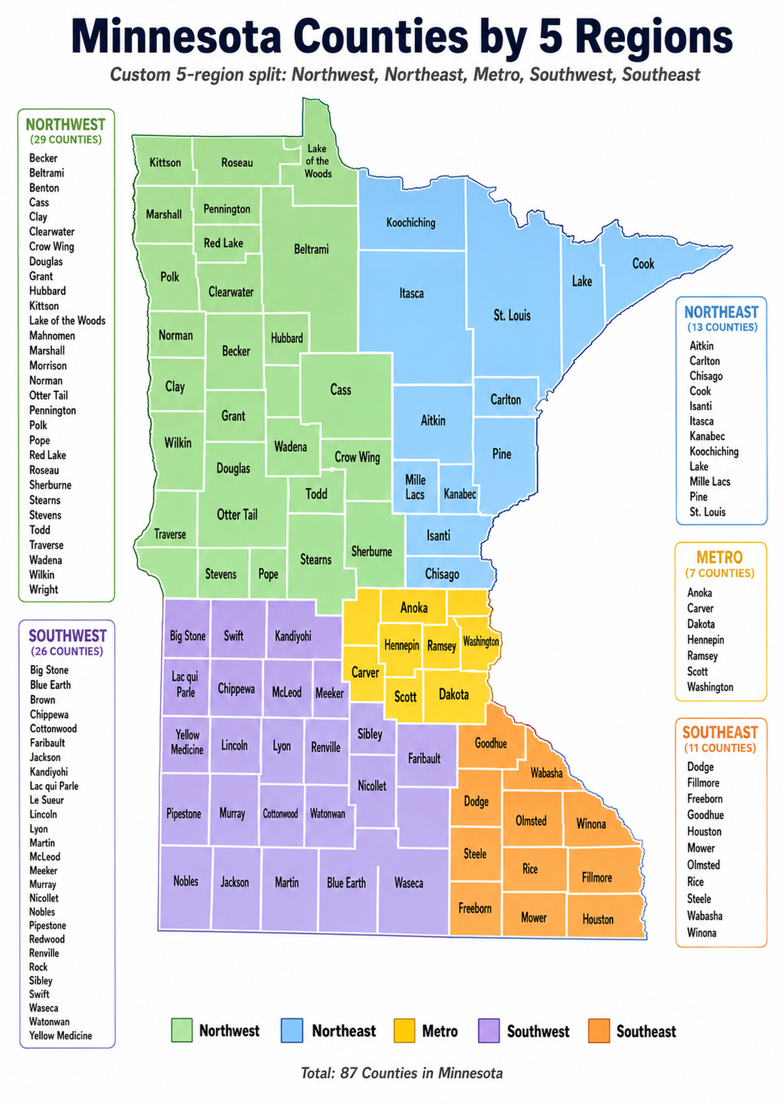
Clickable county map
Open a county directly
The shared five-region county map is kept here only as the approved navigation asset. It is best for people who already know the county name or want to jump from map position to county page.
Kittson County
Roseau County
Lake of the Woods County
Marshall County
Pennington County
Red Lake County
Beltrami County
Polk County
Clearwater County
Mahnomen County
Norman County
Hubbard County
Becker County
Cass County
Clay County
Grant County
Wadena County
Crow Wing County
Wilkin County
Douglas County
Otter Tail County
Todd County
Morrison County
Traverse County
Stevens County
Pope County
Stearns County
Benton County
Sherburne County
Wright County
Koochiching County
Itasca County
St. Louis County
Lake County
Cook County
Aitkin County
Carlton County
Mille Lacs County
Pine County
Kanabec County
Isanti County
Chisago County
Anoka County
Hennepin County
Ramsey County
Washington County
Carver County
Scott County
Dakota County
Big Stone County
Swift County
Kandiyohi County
Lac qui Parle County
Chippewa County
McLeod County
Meeker County
Yellow Medicine County
Lincoln County
Lyon County
Renville County
Pipestone County
Murray County
Cottonwood County
Watonwan County
Nobles County
Jackson County
Martin County
Blue Earth County
Redwood County
Brown County
Sibley County
Nicollet County
Le Sueur County
Waseca County
Faribault County
Rock County
Goodhue County
Wabasha County
Dodge County
Olmsted County
Winona County
Steele County
Rice County
Freeborn County
Mower County
Fillmore County
Houston County
Start with a county region
Browse Counties by Region
Choose a region when the county list needs a travel lens. Each panel explains what the counties are best for, shows a distinct Counties-page-only visual, and gives direct county links so the page feels like a guide instead of a database dump.

Northwest Minnesota
Northwest Minnesota County Guides
Northwest county browsing is the route for visitors choosing between Red Lake country, Lake of the Woods border water, Leech Lake corridors, Detroit Lakes weekends, and forest-to-prairie county transitions. Open this region when the planning question is distance, lodging base, fishing emphasis, and how many big lake systems can fit into one northern trip.
Best for big-water fishing counties, resort corridors, and longer northern drives.
Helpful anchors: Becker, Beltrami, Cass, Clearwater, Hubbard, Lake of the Woods, Otter Tail.
Becker County
Beltrami County
Benton County
Cass County
Clay County
Clearwater County
Crow Wing County
Compare Northwest county lake routes →
Northeast Minnesota
Northeast Minnesota County Guides
Northeast county browsing helps visitors separate Lake Superior shore counties, Boundary Waters gateways, Iron Range lake country, Voyageurs-area routes, and inland forest access. Use this region when the trip needs scenery, cold-water awareness, canoe-country logistics, rocky shoreline context, and county pages that explain why one northeast route feels different from another.
Best for North Shore travel, canoe gateways, rocky water, and forest lake routes.
Helpful anchors: Cook, Lake, St. Louis, Itasca, Koochiching, Pine.
Open Northeast county shore and canoe guides →
Metro Minnesota
Metro Minnesota County Guides
Metro county browsing is for quick decisions: which county has the right mix of beaches, boat launches, trail loops, sailing water, park lakes, suburbs, and city-adjacent lake time. Use it when visitors want a lake plan that also considers traffic, food stops, transit, neighborhoods, repeat day trips, and easy routes back home.
Best for day trips, beaches, sailing, walkable lakes, and family access near the Twin Cities.
Helpful anchors: Hennepin, Ramsey, Dakota, Washington, Anoka, Carver, Scott.
Anoka County
Carver County
Dakota County
Hennepin County
Ramsey County
Scott County
Washington County
Find Metro county lake access →
Southwest Minnesota
Southwest Minnesota County Guides
Southwest county browsing is useful when the goal is prairie water, state-park stops, shore fishing, camping bases, birding wetlands, reservoir routes, and open-sky lake weekends. County pages help visitors understand which lakes are destination anchors and which are better as part of a scenic drive or quiet local stop.
Best for prairie lakes, camping loops, shore fishing, and quieter scenic county routes.
Helpful anchors: Big Stone, Kandiyohi, Pope, Swift, Lyon, Murray, Brown.
Big Stone County
Blue Earth County
Brown County
Chippewa County
Cottonwood County
Faribault County
Jackson County
Browse Southwest county lake plans →
Southeast Minnesota
Southeast Minnesota County Guides
Southeast county browsing connects lake stops with bluffs, wooded valleys, river towns, family beaches, trail corridors, and scenic weekend loops. Use this region when visitors are comparing water with landscape, small-city services, drives through bluff country, paddling ideas, and county pages that make southeast lake travel easier to place.
Best for bluff-country drives, wooded lake stops, trail pairings, and family-friendly routes.
Helpful anchors: Goodhue, Olmsted, Winona, Wabasha, Rice, Freeborn, Fillmore.
Dodge County
Fillmore County
Freeborn County
Goodhue County
Houston County
Mower County
Olmsted County
Compare Southeast county lake routes →Different planning styles
Featured Counties
These examples show how county pages should help visitors choose by geography, lake density, access, recreation style, trip length, and nearby services. Each card uses a Counties-page-only visual and longer local planning copy.

Use for Detroit Lakes access, beach weekends, fishing, resorts, and west-central services.
Becker County
Becker County is a practical west-central starter county because visitors can compare Detroit Lakes energy with quieter lake clusters, public beaches, fishing access, trails, resorts, and road-trip services. It works well when the visitor wants a county page that can support a weekend base instead of a single lake stop.
Plan Becker County lake towns and routes →
Use for Leech Lake, Gull Lake, Winnie, resorts, boat routes, and forest drives.
Cass County
Cass County belongs near the top of any county-first lake plan because it ties together Leech Lake, Lake Winnibigoshish, Gull Lake, the Whitefish Chain, forest routes, resort towns, and fishing communities. Open it when visitors need many large-lake choices in one north-central planning area.
Open Cass County big-lake corridors →
Use for North Shore scenery, Gunflint routes, paddling, waterfalls, and rugged water.
Cook County
Cook County gives the Counties page a very different kind of planning anchor: Lake Superior shore, Gunflint Trail access, canoe-country routes, waterfalls, rocky scenery, and long drives where weather and distance matter. It is the county to open when the trip goal is scenery, paddling, and a stronger northern identity.
Explore Cook County shore and canoe planning →
Use for glacial lake density, cabins, small towns, fishing, and family trips.
Otter Tail County
Otter Tail County is useful for visitors who want classic glacial lake country, small towns, family cabins, rolling roads, fishing, and a very wide county lake network. It helps travelers compare many lake options without assuming one destination lake should define the whole trip.
Compare Otter Tail County lake clusters →
Use for Superior access, Vermilion, Rainy, Kabetogama, Duluth, and Iron Range routes.
St. Louis County
St. Louis County is large enough to need careful county-first planning: Superior shoreline, Duluth-area access, Iron Range communities, Lake Vermilion, Rainy Lake, Kabetogama, forest roads, and Voyageurs-style travel all sit in one county context. Use it when visitors need gateways and route choices, not just a lake list.
Open St. Louis County lake gateways →
Use for city beaches, Lake Minnetonka, Chain of Lakes loops, sailing, and quick day trips.
Hennepin County
Hennepin County shows how urban lake planning works: beaches, park loops, sailing, paddling, Lake Minnetonka access, Minneapolis Chain of Lakes energy, and fast day-trip choices. It is the county to open when visitors want water close to food, neighborhoods, trails, events, and short return drives.
Plan Hennepin County city lake stops →County Fun Facts
These quick signals explain why county pages matter: they turn a huge statewide lake index into local planning routes that visitors can actually use.
Minnesota Counties
Every county has a planned parent page so lake discovery can start with a place visitors already recognize.
Custom Regions
The site groups counties into five practical lake-planning regions instead of a generic statewide dump.
Northwest Counties
Northwest Minnesota has the largest county group, so county pages are essential for narrowing the trip.
Metro Counties
The Metro region is compact, but its county pages carry the heaviest day-trip and access-planning load.
Lake Build Cap
The build plan keeps up to the 100 largest named lakes for each county so county pages stay useful without becoming endless.
Named Lake Pages
The named-lakes plan gives county pages enough depth to become real local discovery hubs.
Direct county directory
All Counties A–Z
Open any Minnesota county page from the compact alphabetical directory. The panel is intentionally dense but scannable, while the region and featured sections above provide the editorial planning context.
C
Carlton CountyCarver CountyCass CountyChippewa CountyChisago CountyClay CountyClearwater CountyCook CountyCottonwood CountyCrow Wing CountyM
Mahnomen CountyMarshall CountyMartin CountyMcLeod CountyMeeker CountyMille Lacs CountyMorrison CountyMower CountyMurray CountyS
Scott CountySherburne CountySibley CountySt. Louis CountyStearns CountySteele CountyStevens CountySwift CountyWhat to do after choosing a county
County Planning & Lake Discovery
County pages are the bridge between statewide browsing and the next decision. Use these paths to move from a county into lake rankings, recreation, fishing access, camping, trails, and lake education without dropping visitors into generic links.

Top Lakes by County
Start with county pages when the visitor wants the largest named lakes, acreage context, nearby communities, and route choices inside one local area. This path is best for turning broad county names into lake-by-lake decisions.
Compare top lakes by county context →
County Recreation
County-first recreation planning connects lake choices with parks, beaches, trailheads, launches, public lands, small towns, and realistic drive times. Use this path when the trip needs a complete day plan rather than a single lake profile.
Build recreation plans from county pages →
Fishing & Water Access
Fishing plans often depend on county context: lake clusters, ramps, bait and service towns, seasonal routes, and official resources. Use this path to move from a county into practical access planning before choosing where to launch or fish from shore.
Open county fishing and access planning →
Camping & Trails
County pages are useful for pairing lake stops with campgrounds, trailheads, scenic drives, nearby towns, and weekend loops. This path helps visitors turn a county into a multi-stop route with places to stay and things to do nearby.
Link counties with camping and trail ideas →
Lake Education
Education pages help visitors interpret what they see on county and lake pages: depth, clarity, aquatic plants, shoreline health, water quality, weather, and invasive-species prevention. Use this path before judging a lake only by a photo or a single statistic.
Use education guides with county planning →